A flat riverside route past London's big landmarks, ending across the water from the Houses of Parliament, ideal for a jet-lagged first afternoon.
Duration
3 hr 30 min
Distance
5.1 km
Difficulty
Easy
Stops
9
Best time
Afternoon, 13:00 to 17:00
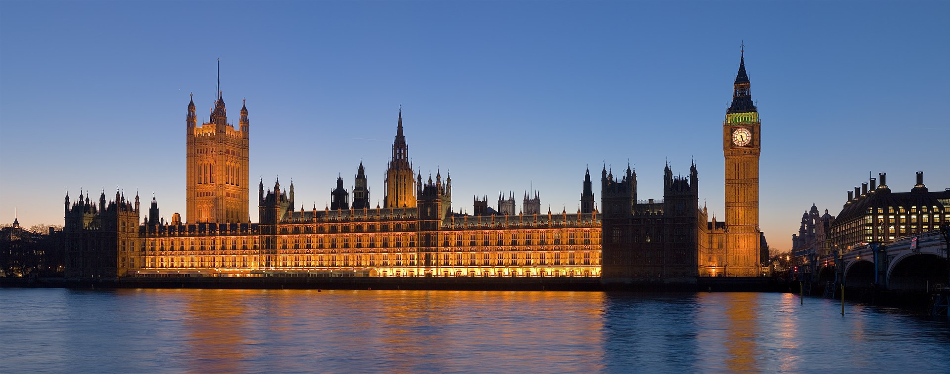
Photo: Palace of Westminster, London - Feb 2007
Start
London Bridge station
Finish
Westminster Bridge
Route map: South Bank First Walk
A Google My Maps embed drops in here. Until then, follow the numbered stops below, they are written so the route works without a live map.
Overview
What this walk is like
London's South Bank is one of the easiest orientation walks in Europe: flat, riverside, and signposted the whole way, with almost every major landmark visible from the path at some point.
This route starts near London Bridge, passes Shakespeare's Globe and the Tate Modern, crosses at the Millennium footbridge, then continues along the water to the London Eye and Westminster.
Because it hugs the river you rarely need to check a map. If in doubt, keep the Thames on your right and you are going the correct way. That kind of route is exactly what you want on the day you land.
Fine for families, easy on tired legs, and it doubles as a good introduction to how the city sits along its river.
3 hr 30 min
5.1 km
Easy
Afternoon, 13:00 to 17:00
Photo: London - Bedale Street - Borough Market II
The route
9 stops, in walking order
Each stop gives you the direction from the previous one, what to look at, a practical tip and roughly how long to stay.
1
Borough Market surrounds
Direction
From London Bridge station, walk south-west along Borough High Street for about 200 m.
What to see
One of London's oldest food markets, under Victorian railway arches. Even outside trading hours the buildings and covered lanes are worth a look.
Navi TipFull stalls run Wednesday to Saturday. On other days some food counters are still open for a quick bite.
Time here: 20 min
2
The Golden Hinde replica
Direction
Cut through the market lanes toward the river, about 150 m.
What to see
A full-size reconstruction of the ship Francis Drake sailed around the world, squeezed into a tiny dry dock between buildings.
Navi TipYou can see the whole thing from outside the fence, no need to pay for the ship tour unless travelling with curious kids.
Time here: 10 min
3
Shakespeare's Globe
Direction
Follow the riverside path west for roughly 500 m.
What to see
A modern rebuild of the open-air Elizabethan theatre, thatched roof and all, standing close to where the original once stood.
Navi TipThe riverside plaza outside is free to walk through and gives a clear view of the timber frame without a ticket.
Time here: 15 min
4
Tate Modern
Direction
Continue along the path for about 400 m until the tall brick chimney comes into view.
What to see
A former power station converted into one of the world's larger modern art museums. The building alone, all brick and one huge chimney, is worth the stop.
Navi TipGeneral admission to the permanent collection is free. Only the temporary exhibitions charge.
Time here: 20 min
5
Millennium Bridge
Direction
The footbridge is right beside the Tate, crossing the Thames toward St Paul's.
What to see
A slim steel pedestrian bridge with St Paul's Cathedral framed directly ahead. It swayed noticeably when it first opened, which locals have not let it forget.
Navi TipBest photo spot is the middle of the bridge looking north, early morning light works well if you happen to pass again then.
Time here: 10 min
Photo: London - Hopton Street - View East on Tate Modern's Birch Trees
6
Back along the South Bank to the OXO Tower
Direction
Return south over the bridge and continue west along the riverside path for about 800 m.
What to see
An Art Deco tower originally built to skirt advertising rules by spelling out OXO in its window design. Now home to small design studios and a rooftop restaurant.
Navi TipThe public viewing gallery at the top is free and usually quiet, a good rest stop with a river view.
Time here: 15 min
7
National Theatre and Royal Festival Hall
Direction
Keep walking west along the path for roughly 700 m.
What to see
A stretch of brutalist and mid-century cultural buildings that some visitors dislike on sight and grow fond of by the end of the trip. There is usually something free happening on the terraces.
Navi TipCheck the noticeboards outside, there are often free lunchtime music sessions in the Festival Hall foyer.
Time here: 15 min
8
The London Eye
Direction
Continue along the path for about 600 m.
What to see
A large observation wheel on the river's edge, one of the most recognisable additions to London's skyline in recent decades.
Navi TipYou do not need a ticket to appreciate it from below. If you do want to ride, book a time slot online rather than queuing on the day.
Time here: 15 min
9
Westminster Bridge
Direction
Walk the final 300 m to the bridge, with the Houses of Parliament directly across the water.
What to see
One of the classic London views: Big Ben's clock tower and the Houses of Parliament seen across the Thames, especially good as the light starts to change.
Navi TipCross to the far side for the postcard photo, then Westminster Underground station is right there if you are ready to head off.
Time here: 20 min
Before you go
Small things that change the walk
A waterproof layer. Weather on the South Bank changes fast and there is little cover along the path.
Comfortable shoes, the whole route is flat but paved the entire way.
An Oyster card or contactless bank card ready, useful once you are done and need the Tube.
Screenshots of the route saved, signal is fine here but battery drains fast with the camera out constantly.
Small cash or card for a snack from Borough Market if you start hungry.
Check opening times for the Tate Modern if you want to go inside, it is closed on a few public holidays.
Checklist
Tick these off at the hotel
Screenshot Mode
Screenshot these cards before you leave.
Save each card to your phone gallery in order. On the walk you swipe through the screenshots instead of loading maps. No app, no data, no dead battery from GPS.
Card 1 of 12Route
London
South Bank First Walk
Duration
3 hr 30 min
Distance
5.1 km
Difficulty
Easy
Stops
9
Start
London Bridge station
Finish
Westminster Bridge
NaviTraveler - no signal needed
Card 2 of 12Stop 1
Borough Market surrounds
Direction From London Bridge station, walk south-west along Borough High Street for about 200 m.
See One of London's oldest food markets, under Victorian railway arches. Even outside trading hours the buildings and covered lanes are worth a look.
Navi Tip Full stalls run Wednesday to Saturday. On other days some food counters are still open for a quick bite.
Time here: 20 min
NaviTraveler - no signal needed
Card 3 of 12Stop 2
The Golden Hinde replica
Direction Cut through the market lanes toward the river, about 150 m.
See A full-size reconstruction of the ship Francis Drake sailed around the world, squeezed into a tiny dry dock between buildings.
Navi Tip You can see the whole thing from outside the fence, no need to pay for the ship tour unless travelling with curious kids.
Time here: 10 min
NaviTraveler - no signal needed
Card 4 of 12Stop 3
Shakespeare's Globe
Direction Follow the riverside path west for roughly 500 m.
See A modern rebuild of the open-air Elizabethan theatre, thatched roof and all, standing close to where the original once stood.
Navi Tip The riverside plaza outside is free to walk through and gives a clear view of the timber frame without a ticket.
Time here: 15 min
NaviTraveler - no signal needed
Card 5 of 12Stop 4
Tate Modern
Direction Continue along the path for about 400 m until the tall brick chimney comes into view.
See A former power station converted into one of the world's larger modern art museums. The building alone, all brick and one huge chimney, is worth the stop.
Navi Tip General admission to the permanent collection is free. Only the temporary exhibitions charge.
Time here: 20 min
NaviTraveler - no signal needed
Card 6 of 12Stop 5
Millennium Bridge
Direction The footbridge is right beside the Tate, crossing the Thames toward St Paul's.
See A slim steel pedestrian bridge with St Paul's Cathedral framed directly ahead. It swayed noticeably when it first opened, which locals have not let it forget.
Navi Tip Best photo spot is the middle of the bridge looking north, early morning light works well if you happen to pass again then.
Time here: 10 min
NaviTraveler - no signal needed
Card 7 of 12Stop 6
Back along the South Bank to the OXO Tower
Direction Return south over the bridge and continue west along the riverside path for about 800 m.
See An Art Deco tower originally built to skirt advertising rules by spelling out OXO in its window design. Now home to small design studios and a rooftop restaurant.
Navi Tip The public viewing gallery at the top is free and usually quiet, a good rest stop with a river view.
Time here: 15 min
NaviTraveler - no signal needed
Card 8 of 12Stop 7
National Theatre and Royal Festival Hall
Direction Keep walking west along the path for roughly 700 m.
See A stretch of brutalist and mid-century cultural buildings that some visitors dislike on sight and grow fond of by the end of the trip. There is usually something free happening on the terraces.
Navi Tip Check the noticeboards outside, there are often free lunchtime music sessions in the Festival Hall foyer.
Time here: 15 min
NaviTraveler - no signal needed
Card 9 of 12Stop 8
The London Eye
Direction Continue along the path for about 600 m.
See A large observation wheel on the river's edge, one of the most recognisable additions to London's skyline in recent decades.
Navi Tip You do not need a ticket to appreciate it from below. If you do want to ride, book a time slot online rather than queuing on the day.
Time here: 15 min
NaviTraveler - no signal needed
Card 10 of 12Stop 9
Westminster Bridge
Direction Walk the final 300 m to the bridge, with the Houses of Parliament directly across the water.
See One of the classic London views: Big Ben's clock tower and the Houses of Parliament seen across the Thames, especially good as the light starts to change.
Navi Tip Cross to the far side for the postcard photo, then Westminster Underground station is right there if you are ready to head off.
Time here: 20 min
NaviTraveler - no signal needed
Card 11 of 12Checklist
Before You Go
A waterproof layer. Weather on the South Bank changes fast and there is little cover along the path.
Comfortable shoes, the whole route is flat but paved the entire way.
An Oyster card or contactless bank card ready, useful once you are done and need the Tube.
Screenshots of the route saved, signal is fine here but battery drains fast with the camera out constantly.
Small cash or card for a snack from Borough Market if you start hungry.
Check opening times for the Tate Modern if you want to go inside, it is closed on a few public holidays.
NaviTraveler - no signal needed
Card 12 of 12Phrases
Emergency Phrases
English
Where's the nearest loo? Where is the nearest restroom?
How much is this? How much does this cost?
Could you point me the right way? Can you help me with directions?
Cheers Thanks (informal)
Which platform for the Jubilee line? Asking for the correct Underground platform
Emergency number: check the local number for your country before you set off.
NaviTraveler - no signal needed
Swipe sideways to see every card. On a phone, take one screenshot per card.
Emergency phrases
A few words of English
Worth a screenshot of its own. Even a badly pronounced attempt usually gets you help.
Where's the nearest loo?
Where is the nearest restroom?
How much is this?
How much does this cost?
Could you point me the right way?
Can you help me with directions?
Cheers
Thanks (informal)
Which platform for the Jubilee line?
Asking for the correct Underground platform
City notes
Transport, safety and tipping in London
Sprawling but walkable in patches, with parks, the Thames and distinct village-like neighbourhoods to link on foot.


 Rainy Day

